Construction & Site Surveys
Most phase decisions are made with incomplete data.
Yours don't have to be.

FAA-certified drone pilots with military aviation backgrounds — every construction site survey is mission-planned, not improvised
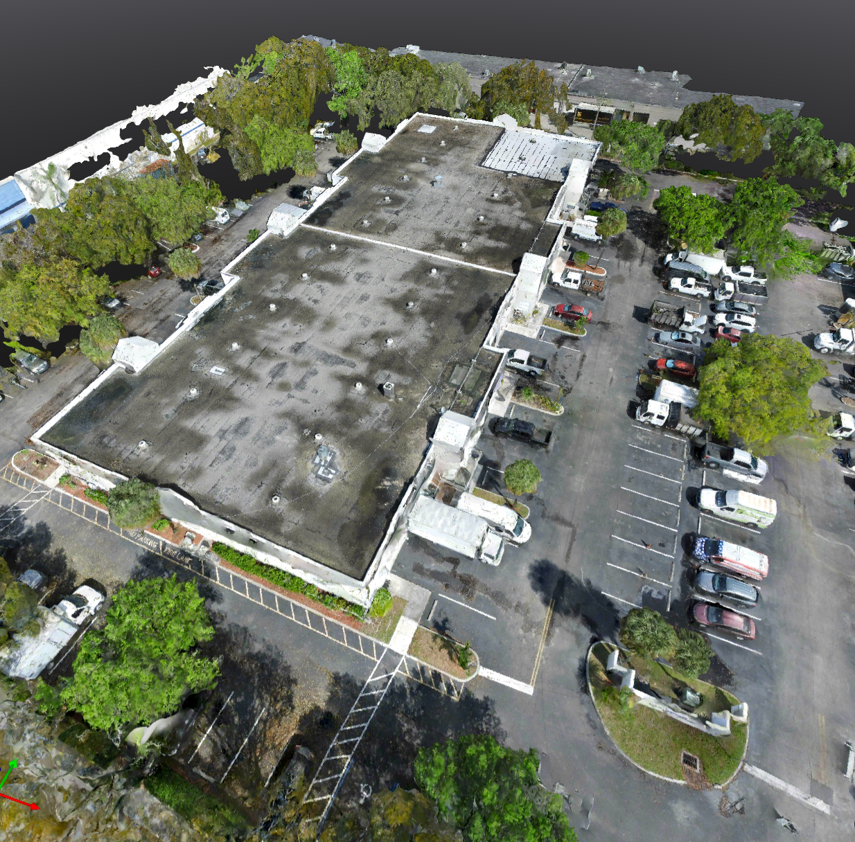
Photogrammetry data collection — orthomosaic maps, 3D point clouds, and digital elevation models accurate to within centimeters
Same-day data delivery to your project portal — processed orthomosaic maps, elevation models, and progress photos before your next phase meeting
Cumulative project documentation from groundbreak to completion — every flight builds on the last so you have a full construction timeline, not just snapshots
Stockpile volumetric calculations and cut/fill analysis — accurate earthwork data that reduces costly over-excavation and material waste on every job
Preferred Provider Agreements for general contractors, developers, and civil engineering firms — consistent crews, priority scheduling, and volume pricing
We deliver construction intelligence, not just aerial photos — georeferenced data your project managers, engineers, and surveyors can act on immediately
THE COST OF BAD SITE DATA
Every construction decision is a terrain decision. Cut too much, fill too little, miss a phase milestone — and the project pays for it. Most drone operators hand you imagery and call it done. Few understand what it actually takes to document a job site from groundbreak to completion.
HOW THE DRONE SITE SURVEY WORKS
We start with a scope call to understand your project — the site, the phase, and the data your team actually needs. Then we fly, process, and deliver. Every deployment is planned to aviation standards and executed the same way every time, whether it's your first scan or your fifteenth.
YOUR CONSTRUCTION SURVEY DELIVERABLES
Accurate volumetrics, elevation models, and progress documentation delivered to your cloud portal. Your complete project history in one place — phase by phase, from groundbreak to completion. Shareable with your whole team the same day it's flown.
DRONE CONSTRUCTION SURVEY SERVICES
AeroVis provides FAA-certified drone construction surveys and site documentation for residential developers, commercial general contractors, civil engineering firms, and land surveyors. Our services include: photogrammetry surveys producing orthomosaic maps, 3D point clouds, and digital elevation models; stockpile volumetric calculations and cut/fill analysis for earthwork management; construction progress documentation from groundbreak to certificate of occupancy; pre-construction topographic surveys for grading and drainage planning; and phase milestone documentation for owner reporting and lender draws. Every survey is scoped to your project specifications, site conditions, and data deliverable requirements — not a one-size-fits-all flight plan.
DRONE CONSTRUCTION SURVEY FAQs
-
AeroVis surveys residential and commercial construction sites of all scales — from single-family home grading and site prep to large commercial developments, multifamily projects, civil infrastructure, and industrial facilities. We work with general contractors, developers, civil engineers, and land surveyors across all project phases from pre-construction topographic surveys through final progress documentation.
-
AeroVis drone surveys using photogrammetry achieve horizontal accuracy of 1-3 cm and vertical accuracy of 2-5 cm with proper ground control points (GCPs), which meets or exceeds the requirements for most construction applications including earthwork calculations, cut/fill analysis, and progress documentation. For projects requiring survey-grade precision, we coordinate GCP placement with licensed land surveyors to ensure data meets your project’s specific accuracy specifications.
-
Drone surveys are a powerful complement to licensed land surveyors but are not a legal replacement for boundary surveys, plats, or other work requiring a licensed professional’s stamp. AeroVis data is ideal for earthwork quantities, progress tracking, and site visualization — and we regularly collaborate directly with survey firms who use our orthomosaic maps and point clouds as efficient base data for their licensed survey work.
-
Flight time for a typical 1-5 acre construction site is 30-60 minutes. Larger sites of 10+ acres may require 1-2 hours of flight time. Data processing and delivery is same-day — processed orthomosaic maps, elevation models, and volumetric reports are delivered to your cloud portal within hours of the flight, before your next project meeting or phase deadline. Repeat interval surveys can be scheduled weekly, biweekly, or monthly on a Preferred Provider Agreement.
-
Yes — AeroVis serves the full range of construction clients. On the residential side: custom home builds, subdivisions, grading contractors, and land developers. On the commercial side: office and retail developments, industrial facilities, multifamily housing, hospitality projects, and civic infrastructure. We also partner with civil engineering firms and land development consultants who need reliable drone data integrated into their project workflows on a recurring basis.
-
Item descriptionStart with a scope call — we’ll review your project timeline, phase milestones, and data requirements. AeroVis offers Preferred Provider Agreements (PPAs) for contractors and developers who need consistent, recurring coverage. PPAs include priority scheduling, volume pricing, and a dedicated project portal where all of your historical flight data, orthomosaic maps, and reports are stored and accessible throughout the full project lifecycle.
Ready to Get Started?
Every project is scoped individually. Book a free 20-minute call and we'll have a proposal back to you the same day.