Back to the Darién: A New Mission Begins
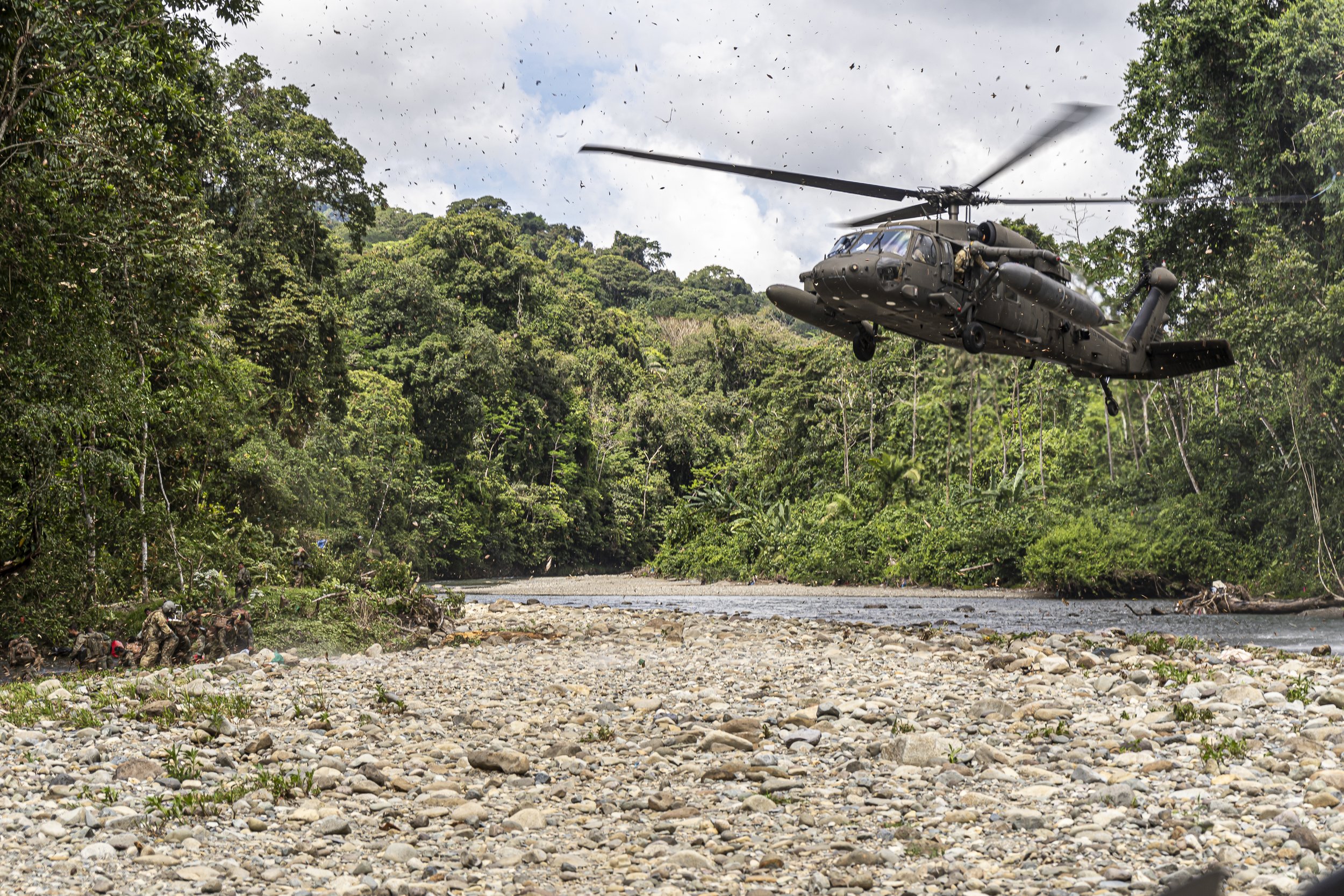
A.CO 228th AVN, UH-60L Landing onto a riverbed in the jungles of Panama.
By Kevin Padilla
It’s been years since I last touched down in the Darién Forest of Panama. Back then, I was flying as an Air Mission Commander, overseeing two helicopters conducting troop movement and resupply missions across some of the most unforgiving terrain on the planet. Those missions taught me respect for both the jungle and the people who call it home.

A photo of me as the Air Mission Commander of 2x UH-60Ls assigned to A.CO 228th AVN while flying from MPPA to our destinations.
I’ll never forget landing beside that river base, with villagers bathing and laughing on one side, and a security contingent stationed on the other. As I sat at flat pitch, rotors still spinning, I remember thinking, What would it be like to live here for a week?


Now, I’m going back — not as a soldier, but as the founder of AeroVis, leading a team to support local scientists studying crocodiles, jaguars, and other species deep within this same forest.
Why Drones Matter in the Darién
Field research in the Darién is as challenging as it is vital. Scientists face physical, logistical, and environmental barriers that limit what can be observed and how safely it can be done. The AeroVis mission is designed to address those exact challenges through disciplined aviation-based drone operations.
Access and Safety
Dense jungle and flooded riverbanks make wildlife access dangerous. Night surveys often require small boats or exposed ground patrols.
Our Solution: Radiometric thermal drones allow safe, non-intrusive observation from the air. We can cover kilometers of terrain without exposing teams to risk, expanding reach and reducing time in hazardous environments.
Detection and Observation Limits
Ground-based surveys rely on narrow visibility and daylight, missing nocturnal and camouflaged species.
Our Solution: The ACSL SOTEN drone’s thermal sensor detects heat signatures of animals hidden in vegetation or moving at night. It turns what was once invisible into measurable data on animal presence and movement.
Spatial Context and Habitat Mapping
Researchers often document animal sightings but lack spatial context about their surrounding environment.
Our Solution: Our 4K EO camera and Pix4D processing generate high-resolution orthomosaics and 3D terrain models. These maps provide measurable context for nesting zones, migration routes, and habitat health.
Data Volume and Consistency
Traditional methods produce fragmented or inconsistent data, making long-term analysis difficult.
Our Solution: Every AeroVis mission produces geotagged, time-stamped, and temperature-coded datasets that integrate into GIS platforms like ArcGIS or QGIS, allowing longitudinal studies and cross-year comparisons.
Equipment and Expertise Gaps
Many regional organizations have basic drones, but lack training or payloads capable of scientific-grade mapping.
Our Solution: AeroVis provides both advanced equipment and trained crews. We deploy, train, and leave systems in-country for sustained research capability.
Funding and Publication Pressure
Conservation efforts depend on visual and data-driven outputs to secure support and publication credibility.
Our Solution: Our deliverables include thermal detection maps, 3D models, vegetation overlays, and GIS-ready data that strengthen proposals, attract funding, and enhance scientific visibility.
Building Capacity for the Long Term
Everywhere we operate, our goal is to leave behind more than footage and data. The Darién mission represents a new kind of collaboration between aviation professionals and environmental scientists. It is about merging operational precision with ecological purpose.
We are building systems that transfer capability, not dependence. When we leave Panama, local teams will have the drones, the data pipelines, and the workflows to continue the mission on their own. This model is scalable to other regions facing similar challenges, from dense jungles to coastal wetlands.
What makes it different is that it is built from a foundation of aviation discipline: preflight checklists, data traceability, and repeatable processes. The same principles that keep aircraft safe can now protect scientists, safeguard wildlife, and preserve critical ecosystems.
In the long term, our intent is to help research and conservation teams build self-sustaining aerial programs that generate data as reliable as any flight log. That consistency creates credibility, and credibility drives global collaboration and conservation funding.
What’s Next
If all goes according to plan, we’ll return to Panama in February 2026 for the first series of flights. The logistics are already complex, but that’s part of the draw.
We’ll be operating in some of the most remote terrain in the hemisphere, where the landscape shifts from river delta to rainforest within a few miles. Each sortie will collect data that helps identify where apex predators thrive and how their ecosystems evolve through the seasons.
For me, this mission feels like a full circle. Years ago, I flew over this same landscape with a different purpose. This time, I’ll be returning to the same jungle, not to supply troops, but to support the people protecting what remains wild.
AeroVis was built on that idea — that aviation discipline and precision can serve something greater than the mission alone. The Darién will be our first step in proving it.
It’s been years since I last touched down in the Darién Forest of Panama. Back then, I was flying as an Air Mission Commander, overseeing two helicopters conducting troop movement and resupply missions across some of the most unforgiving terrain on the planet. Those missions taught me respect for both the jungle and the people who call it home.
I’ll never forget landing beside that river base, with villagers bathing and laughing on one side, and a security contingent stationed on the other. As I sat at flat pitch, rotors still spinning, I remember thinking, What would it be like to live here for a week?
Now, I’m going back — not as a soldier, but as the founder of AeroVis, leading a team to support local scientists studying crocodiles, jaguars, and other species deep within this same forest.
Why Drones Matter in the Darién
Field research in the Darién is as challenging as it is vital. Scientists face physical, logistical, and environmental barriers that limit what can be observed and how safely it can be done. The AeroVis mission is designed to address those exact challenges through disciplined aviation-based drone operations.
Access and Safety
Dense jungle and flooded riverbanks make wildlife access dangerous. Night surveys often require small boats or exposed ground patrols.
Our Solution: Radiometric thermal drones allow safe, non-intrusive observation from the air. We can cover kilometers of terrain without exposing teams to risk, expanding reach and reducing time in hazardous environments.
Detection and Observation Limits
Ground-based surveys rely on narrow visibility and daylight, missing nocturnal and camouflaged species.
Our Solution: The ACSL SOTEN drone’s thermal sensor detects heat signatures of animals hidden in vegetation or moving at night. It turns what was once invisible into measurable data on animal presence and movement.
Spatial Context and Habitat Mapping
Researchers often document animal sightings but lack spatial context about their surrounding environment.
Our Solution: Our 4K EO camera and Pix4D processing generate high-resolution orthomosaics and 3D terrain models. These maps provide measurable context for nesting zones, migration routes, and habitat health.
Data Volume and Consistency
Traditional methods produce fragmented or inconsistent data, making long-term analysis difficult.
Our Solution: Every AeroVis mission produces geotagged, time-stamped, and temperature-coded datasets that integrate into GIS platforms like ArcGIS or QGIS, allowing longitudinal studies and cross-year comparisons.
Equipment and Expertise Gaps
Many regional organizations have basic drones, but lack training or payloads capable of scientific-grade mapping.
Our Solution: AeroVis provides both advanced equipment and trained crews. We deploy, train, and leave systems in-country for sustained research capability.
Funding and Publication Pressure
Conservation efforts depend on visual and data-driven outputs to secure support and publication credibility.
Our Solution: Our deliverables include thermal detection maps, 3D models, vegetation overlays, and GIS-ready data that strengthen proposals, attract funding, and enhance scientific visibility.
Building Capacity for the Long Term
Everywhere we operate, our goal is to leave behind more than footage and data. The Darién mission represents a new kind of collaboration between aviation professionals and environmental scientists. It is about merging operational precision with ecological purpose.
We are building systems that transfer capability, not dependence. When we leave Panama, local teams will have the drones, the data pipelines, and the workflows to continue the mission on their own. This model is scalable to other regions facing similar challenges, from dense jungles to coastal wetlands.
What makes it different is that it is built from a foundation of aviation discipline: preflight checklists, data traceability, and repeatable processes. The same principles that keep aircraft safe can now protect scientists, safeguard wildlife, and preserve critical ecosystems.
In the long term, our intent is to help research and conservation teams build self-sustaining aerial programs that generate data as reliable as any flight log. That consistency creates credibility, and credibility drives global collaboration and conservation funding.
What’s Next
If all goes according to plan, we’ll return to Panama in February 2026 for the first series of flights. The logistics are already complex, but that’s part of the draw.
We’ll be operating in some of the most remote terrain in the hemisphere, where the landscape shifts from river delta to rainforest within a few miles. Each sortie will collect data that helps identify where apex predators thrive and how their ecosystems evolve through the seasons.
For me, this mission feels like a full circle. Years ago, I flew over this same landscape with a different purpose. This time, I’ll be returning to the same jungle, not to supply troops, but to support the people protecting what remains wild.
AeroVis was built on that idea — that aviation discipline and precision can serve something greater than the mission alone. The Darién will be our first step in proving it.
Above. It. All.